
CERC — Environmental Software and Services

- Overview
- Atmospheric dispersion
- Atmospheric chemistry
- Urban air quality
- Regional to local air quality modelling
- Vehicles and roads
- Aviation
- Emissions
- Urban heat island
- Atmospheric boundary layer
- Wind energy
- Hazardous releases
- Inverse dispersion modelling
- Net Zero
- Model evaluation
- Smart cities
- Web platforms
- Older projects
- CERC co-author publications
- CERC software publications
- Presentations
Vehicles and roads
Quick links: UK-US collaboration Street canyons Road tunnels Elevated roads Non-exhaust particulates
Vehicle exhaust locations DMRB screening method revision
Pollutant emissions from road vehicles are a key component of urban air quality issues. CERCs models ADMS-Roads, ADMS-Urban and ADMS-Airport include a dedicated road source type, which includes representation of vehicle-induced turbulence. Detailed modelling of complex road geometries such as street canyons, noise barriers and road tunnels can also be included.
Roads vehicle emissions are an active research topic, with discrepancies between standard emission factor values and those measured in real-world conditions. CERCs emissions tool EMIT can be used to make detailed calculations of road emissions including variations of fleet characteristics and accounting for real-world emissions.
UK-US collaboration on evaluation of road source modelling tools
The US Environmental Protection Agency, UK Environment Agency and Defra signed an agreement to cooperate on Air Quality Modelling and Exposure Science in 2008, holding annual meetings alternately in the UK and US. CERC are active participants in these meetings, in particular focusing on aspects of local dispersion modelling. This has led to productive collaborations with staff from the USEPA Office of Research and Development on evaluation of road source modelling tools, using experimental data ranging from an idealised line source in a wind tunnel or at full scale to high-resolution measurements in urban areas. The effects of roadside noise barriers on dispersion from road sources have also been investigated. These evaluation studies have contributed to improvements in road source modelling in the ADMS-Urban and ADMS-Roads models.
Development of advanced street canyon modelling

A project funded by the Hong Kong Environmental Protection Department and in collaboration with the Hong Kong University of Science and Technology led to the development of advanced street canyon modelling techniques in ADMS-Urban. Modelling the complex urban landscape of Hong Kong, with closely-packed but irregularly distributed tall buildings, required a model for street canyon effects which would take into account channeling of pollutants along the canyon, transport and trapping of pollutants in recirculating flow within the canyon, and dispersion of emissions out of the canyon through gaps between buildings, from the top of the canyon or the end of the canyon. There is also the option to include consideration of network effects, where pollutants reaching the end of one street canyon can pass into a connected canyon. The effects of asymmetry in the properties of each side of the canyon are also included. The advanced street canyon module has been evaluated in Hong Kong and London.
Development of road tunnel emissions modelling
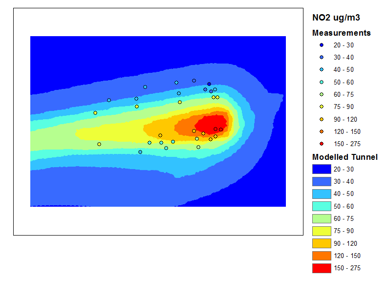
Comparison of modelled and measured concentrations for 3 month period at the Bell Common Tunnel on the M25 (UK).
The development of automated road tunnel emissions modelling in ADMS-Urban and ADMS-Roads was motivated by user requests. The method for modelling tunnel portal emissions using volume sources is based on research by Ginzburg and Schattanek. This approach replaces emissions from a road source defined as being in a tunnel with volume sources outside the portal and/or point or area ventilation sources. The volume sources used to represent portal emissions have lengths and emissions fractions dependent on wind speed and traffic speed, and are defined along the path of an outflow road to represent the entrainment of tunnel emissions in the wakes of vehicles leaving the tunnel. The model has been validated against measurements in the UK and Austria. It has also been used in modelling the local air quality effects of urban road tunnels in Singapore and Glasgow.
Development of elevated road modelling
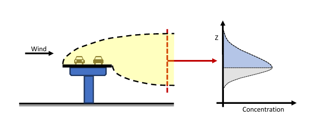
CERC have developed a methodology for modelling dispersion of pollution from roads above ground level, for example bridges and flyovers. The downward dispersal of emissions from an elevated road will only occur after the material has been advected past the downwind edge of the road. Therefore, the downward spread of the plume is limited during its traversal over the road surface. The methodology was evaluated using data from two reference monitors located adjacent to an elevated section of the M4 motorway in London, UK.
The work was funded by Highways England (now National Highways) under the SBRI Innovate UK Developing digital roads and improving air quality competition.
Non-exhaust particulate matter emissions from road traffic
CERC, TRL Limited and the Division of Environmental Health and Risk Management at Birmingham University were commissioned by Defra and the Devolved Administrations (Project CPEA23/SPU82) to investigate non-exhaust emissions of particulate matter (PM) from road traffic. The overall aim of the project was to develop improved prediction methods for emissions and air pollution, primarily for use in the UK National Atmospheric Emissions Inventory (NAEI), based on the existing literature and data.

The project was divided into five main tasks:
- Task 1: A literature review
- Task 2: Emission model evaluation, development and application
- Task 3: Initial air pollution model development and application
- Task 4: Further air pollution model development
- Task 5: Discussion of abatement options
As part of Task 3 of this project, CERC investigated the accuracy of the most up-to-date estimates of non-exhaust particulate (PM10 and PM2.5) emissions by undertaking air dispersion modelling studies at a number of urban sites within the United Kingdom. At these sites, the particulate emissions were modelled using ADMS-Urban, and the predicted pollutant concentrations compared with measured values; comparisons were generally good, in particular for PM10. In terms of source apportionment, the fraction of PM10 concentrations that are due to non-exhaust particulate emissions is almost half of the total traffic source contribution (see figure).
The project ran between 2005 and 2006.
The impact of vehicle exhaust location on initial dispersion[top]

In 2005 CERC, working on behalf of Defra, compiled data on the exhaust characteristics of cars, LGVs, buses and HGVs.
The exhaust of some types of HGV may be configured horizontally, or vertically with the exhaust exit above the vehicle (see picture).
In the United Kingdom buses currently use low level horizontal exhaust but one type with vertical elevated exhausts was expected to become available at that time.
Model calculations demonstrated the significant reduction in ground level concentrations that are gained by using vertically orientated exhausts with elevated outlets. Additional conversion of HGVs and buses to such configurations would increase this effect.
Revision to the DMRB Air Quality Screening Method for use in GIS
The Design Manual for Roads and Bridges (DMRB), volume 11, section 3, details a calculation method for estimating the impact that road projects may have on local and regional air quality. This project, in which CERC were working with Atkins for the Highways Agency (now National Highways), involved the development of an updated version of the air quality tool to be used within a new GIS-based version of the DMRB.
By running a number of modelling scenarios using ADMS-Roads, CERC were able to propose a number of improvements to the current DMRB methodology, including accounting for:

- differing road widths;
- differing road orientations;
- variable canyon height; and
- vehicle-induced turbulence.
In addition, CERC proposed a method that allows the calculations to be performed for road segments, as opposed to roads of infinite length. This was required in order to allow the new implementation of DMRB to be applied within a GIS.
An extensive ADMS-Roads model validation exercise was performed as part of this project, which ran between 2005 and 2006.