
CERC — Environmental Software and Services

- Overview
- Atmospheric dispersion
- Atmospheric chemistry
- Urban air quality
- Regional to local air quality modelling
- Vehicles and roads
- Aviation
- Emissions
- Urban heat island
- Atmospheric boundary layer
- Wind energy
- Hazardous releases
- Inverse dispersion modelling
- Net Zero
- Model evaluation
- Smart cities
- Web platforms
- Older projects
- CERC co-author publications
- CERC software publications
- Presentations
Urban heat island
Quick links:Climate change mitigation City scale temperature forecasting LUCID

Near-surface air temperature perturbation at 50 m x 50 m resolution over Birmingham, UK July 2019 average, modelled using ADMS-Urban (taken from 'Modelling temperature variations in Birmingham, UK at the neighbourhood scale: Using ADMS-Urban climate model', Zhong et al., 2025)
The built environment affects local climate due to the thermal and morphological properties of urban areas. In addition, anthropogenic (man-made) heat emissions from buildings and traffic are higher within urban areas. Thus, urban areas typically experience higher temperatures than rural areas, particularly in the late afternoon and early evening in the summer; this phenomena is known as the 'urban heat island' (UHI) effect.
UHIs have benefits in winter, with lower energy usage for heating, but drawbacks in summer including higher energy usage for air conditioning and higher incidences of heat-related illnesses and deaths. The adverse consequences of UHIs are increasingly of concern to national and local planning authorities. Conversely, local governments are interested in the positive implications of 'green infrastructure' (e.g. an increase in green space in urban areas), which include elevated community health and well-being alongside improvements in air quality. Also, new developments can be designed, constructed and operated with minimal impact on the local climate.
The ADMS-Urban Temperature and Humidity model has been developed to assess, at user-defined spatial resolution, the variation of temperature over complex urban areas. The system consists of two components:
- A land use model in which perturbations to the mean temperature are related to the spatial variation of surface type and building morphology; parameters are used to represent the following land use features: surface roughness, albedo, thermal admittance, surface resistance to evaporation and building volume; and
- An anthropogenic heat model, which allows for the dispersion of the heat emitted from anthropogenic sources. The emissions of heat generated from sources such as buildings and traffic can be modelled at a high resolution (tens of metres), including the effects of the hourly variations of emission rates.
The model has wide-ranging applicability, with examples including:
- Temperature variations in Birmingham City have been modelled by a group from the University of Birmingham (Zhong et al., 2025)
- Beijing's Urban heat Island has been modelled by academics from the University of Edinburgh (Biggart et al., 2021)
- The importance of urban datasets that provide information about building materials, rather than use, is discussed by a group from UCL in relation to the impact on modelled air temperatures (Aktas et al., 2017)
- The strength and spatial distribution of Barcelona's Urban Heat Island has been assessed by group from Barcelona Regional S.A. Urban Development Agency (Carbonell et al., 2017)
- A model evaluation exercise by researchers from the University of Bologna, in which modelled temperatures from the ADMS-Urban Temperature and Humidity model were compared to ENVI-met outputs, has been reported in the literature (Maggiotto et al., 2014)
- CERC have presented model evaluation results for London
Projects involving the modelling of green infrastructure climate change mitigation scenarios and the development of high-resolution city-scale temperature forecasting are described in more detail below. The EPSRC-funded 'Local Urban Climate Model and its Application to the Intelligent Design of Cities' (LUCID) project, for which the ADMS-Urban Temperature and Humidity model was initially developed, is also reported.
Modelling green infrastructure climate change mitigation scenarios
Researchers from the School of Civil and Environmental Engineering at the University of Surrey developed an ADMS-Urban Temperature and Humidity model application for the city of Guildford, UK. They used their model to assess the impacts of differing amounts of green infrastructure on ambient temperatures, specifically: green roofs, grass and trees. Their modelling delivered high spatial resolution (10 m) temperature maps over a study area of approximately 75 km2. A detailed description of their study and the associated modelling outcomes is given in their paper (Tiwari et al., 2020).
In collaboration with CERC, researchers from The Bartlett (University College London) have used the ADMS-Urban Temperature and Humidity model during a study to assess the effectiveness of retrofitting green and cool roofs on reducing energy use within a typical office in central London (Virk et al., 2015). By using the microclimate model output from ADMS-Urban as input to a building thermal simulation model, they were able to show that green and cool roofs reduced annual energy use. The same group looked at the impact of retrofitting green and cool roofs on overheating within a naturally ventilated building (Virk et al., 2014). Both studies considered impacts for current and future climate scenarios.
High-resolution, city-scale temperature forecasting systems
London forecasting
CERC were partners on the 'Disaster Resilient Cities: Forecasting Local Level Climate Extremes and Physical Hazards for Kuala Lumpur' project, funded jointly by the UK and Malaysian governments through the Newton-Ungku Omar Fund. The ADMS-Urban Temperature and Humidity model was used to predict temperature variations within Kuala Lumpur (KL); model predictions were evaluated using Land Surface Temperatures derived from Landsat 8 satellite imagery. Once the model had been configured to represent KLs tropical urban climate, it was incorporated within an operational forecasting system, thus allowing temperature forecasts to be delivered to a prototype multi-hazard platform for managing and communicating risks to enhance disaster resilience; air quality forecasts generated by ADMS-Urban were also delivered to the platform. Baseline temperature modelling outcomes were published (Wang et al., 2019). Under the same project, ADMS-Urban modelled flow field estimates were combined with temperatures measured at a number of locations within KL to calculate a range of thermal comfort metrics (Aktas et al., 2020).
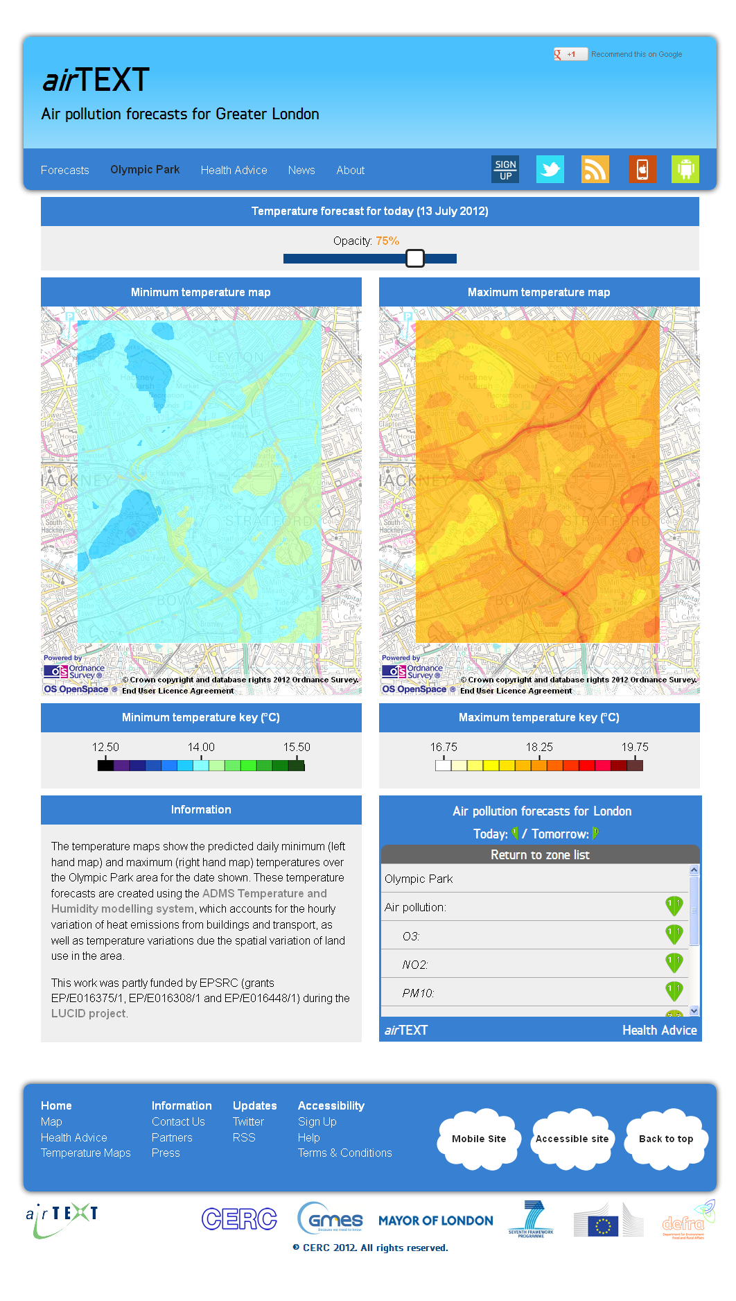
The LUCID ADMS-Urban Temperature and Humidity model configuration for the Olympic Park (Hamilton et al., 2014) was incorporated within a CERC's airTEXT air quality forecasting system to forecast temperatures during the London 2012 Olympics.
LUCID: the intelligent design of cities
The Development of a Local Urban Climate Model and its Application to the Intelligent Design of Cities project (LUCID) was a 3-year research project investigating how cities may adapt to a changing climate. CERC worked on this project between 2007 and 2010, with partners in the academic sector (University College London, London School of Hygiene and Tropical Medicine, University of Reading and Brunel University) as well as other consultancies.
The role of CERC within the project was to develop a tool for modelling changes in temperature and specific humidity on a neighbourhood scale (i.e. over areas of a few square kilometres) due to changing land use. This led to the initial development of the ADMS Temperature and Humidity model for land use effects on temperature. In addition, for the purpose of full model validation against temperature measurements, anthropogenic heat emissions from traffic and buildings were also modelled.

The project, funded by the UK Engineering and Physical Sciences Research Council (EPSRC), led to a number of publications including:
- 'The comfort, energy and health implications of London's urban heat island' (Mavrogianni et al., 2011), which was an overview of the project; and
- 'The impact of the London Olympic Parkland on the urban heat island' (Hamilton et al., 2014), which demonstrated how ADMS can be used to predict temperature changes arising from alterations to land use, such as the development of London's Olympic Parkland.