
CERC — Environmental Software and Services
- Overview
- Air pollution modelling
- ADMS 6
- ADMS-Roads (Extra)
- ADMS-Urban
- MAQS
- ADMS-Airport
- ADMS-Screen
- Feature comparison
- Emissions management
- EMIT
- Wind energy and airflow
- FLOWSTAR-Energy
- Accidental releases
- GASTAR
- LSMS
- ADMS-Puff
- ADMS-STAR
- Managing model runs
- Run Manager
- Model evaluation
- Model Evaluation Toolkit
- Meteorological data processing
- WRFtoMet
- Related Documentation
- User guides
- Technical specifications
- Model validation
- Newsletters
- Publications
- CERC co-author publications
- CERC software publications
- Presentations
- Other information
- Traffic emissions
- Prices
- Free demo
- Visualisation tools
- Current software versions
- System requirements

MAQS (formerly ADMS-Urban RML)
Multi-Model Air Quality System
What is MAQS?
The Multi-Model Air Quality System (MAQS) is an automated system for coupling the high-resolution ADMS-Urban air dispersion model to a regional air quality model with hourly concentration output such as CMAQ, CAMx, EMEP, CHIMERE or WRF-Chem. Other regional models are supported via generic model file formats. Gridded annual average background concentration data (for instance, as generated by PCM in the UK) can be used in lieu of hourly regional model data. Coupled system output comprises predictions of pollutant concentrations for a specified domain, which takes into account both regional and local pollutant transport and chemistry effects.
The aim of the MAQS coupled system is to combine the complementary advantages of regional and local models to improve the prediction of concentration values for all types of receptors:
- Regional (usually Eulerian) models contain complex chemistry mechanisms, which act over long spatial and temporal scales, and can model the accumulation of concentrations in very low wind speed conditions. These grid-based chemical transport models (CTMs) do not resolve the high gradients of concentration close to individual sources such as roads.
- Local (usually Gaussian-type plume) models can represent the fine-scale concentration gradients from explicitly defined sources in detail, but generally only account for simplified chemical mechanisms and spatially homogeneous meteorological data, limiting their applicability for receptors far from the source (e.g. more than 50 km).
Coupling local and regional models allows both the resolution of high concentration gradients close to a source, and the accurate representation of transport and chemistry over large spatial and temporal scales. MAQS combines regional and local concentrations in such a way as to minimise double-counting of emissions, while remaining computationally efficient and user-friendly. Meteorological data from the WRF meso-scale model (or another model with output converted to 'generic' input file format) is used for both the regional modelling and the local modelling.
MAQS runs on Linux and comprises:
- The ADMS-Urban dispersion model (Linux executable and Windows interface)
- Tools to process the regional model data
- Software to automate running these components, including parallelisation
- A post-processing suite for generating pollution maps and/or numerical outputs with options for temporal and/or spatial data aggregation and subsetting
MAQS is supplied with an ADMS-Urban Windows interface for generating input files containing local emissions and specifying output point locations. Under the MAQS-Health project, CERC developed MAQS to support 'generic' input formats for meteorological and concentration data, allowing data from other regional models to be converted for use in the system.
Typical applications of MAQS include:
- Developing and testing the impact of regional and local air quality management policies on pollutant concentrations throughout complex urban areas
- Exposure assessments combining pollutant concentrations over specified areas with population and and health impact data
- Provision of detailed street-scale air quality forecasts for an urban area in combination with a regional scale forecast for surrounding rural areas
Who uses MAQS?
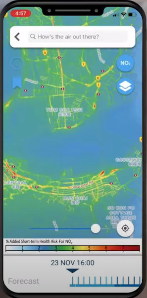
PRAISE-HK Air Quality and Exposure Health Risk information app.
MAQS is for current users of regional air dispersion models who wish to increase the resolution of their modelling over urban areas to take account of street-scale concentration gradients in a computationally efficient way, and for users of ADMS-Urban who wish to account for regional variations in meteorology and background pollutant concentrations. The MAQS design allows regional and local modelling to be performed separately, facilitating collaborations between regional and local modelling specialists and allowing a single set of regional modelling data to be used to test many local modelling scenarios.
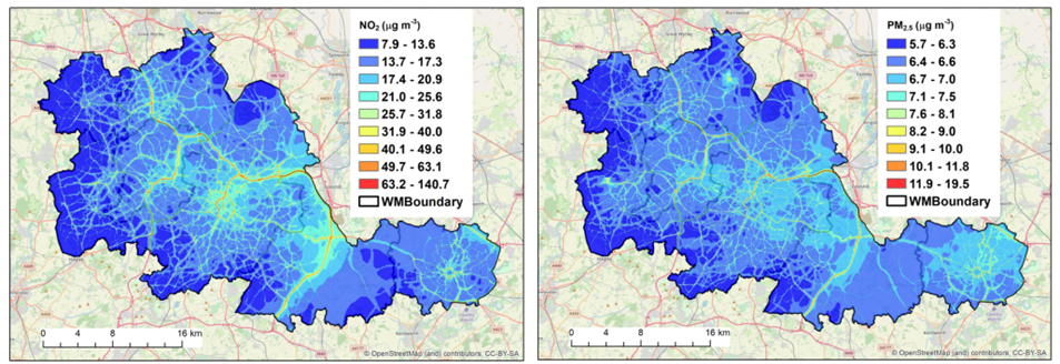
Annual average NO2 and PM2.5 concentrations for the West Midlands (UK), modelled at street scale resolution using MAQS as part of the WM-Air project. From Zhong et al. (2022).
Pioneering uses of MAQS include:
- A group at the Hong Kong University of Science and Technology (HKUST) originally configured MAQS for the Hong Kong Special Administrative Region in a project for the Hong Kong Environmental Protection Department. Regional model data was taken from the CAMx model. In a follow-on project, PRAISE-HK generates daily street-scale air quality forecasts for Hong Kong using MAQS, incorporating regional CMAQ forecasts. Pollution exposure data and associated health advice is made publicly accessible via an app.
- Working with EMEP regional model data generated by UK CEH, CERC used MAQS to model the Republic of Ireland for the Irish Environmental Protection Agency, with pollution maps generated at 20 m resolution across the whole country, and 5 m resolution within five major cities.
- Under the MAQS-Health project, partners from the Universities of Edinburgh, Birmingham and Lancaster and the UK Met Office tested the system with a range of regional models and domains.
- University of Birmingham researchers collaborated with CERC in the WM-Air project, which used MAQS to model street-scale air quality in the West Midlands region of the UK.
- Working with CERC, researchers from the Guangzhou HKUST Fok Ying Tung Research Institute configured MAQS to assess the impact of implementing traffic and industrial source pollution mitigation scenarios on a range of toxic air pollutants, including ozone.
Why use MAQS?
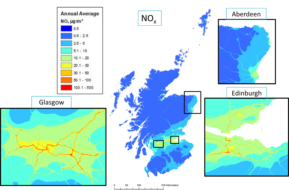
Annual average NOx concentrations for Scotland in 2018, modelling with the MAQS-Health coupled system led by the University of Edinburgh.
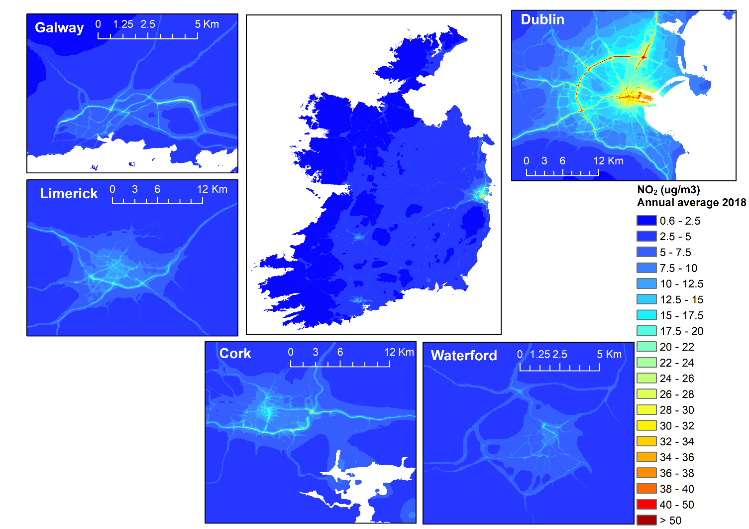
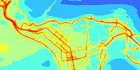
Coupled system annual average NO2 pollution maps for 2019 with high resolution insets of Dublin, Galway, Limerick, Cork and Waterford.
Coupling the local model ADMS-Urban within a regional model using MAQS allows both the resolution of high concentration gradients close to a source, and the accurate representation of transport and chemistry over larger spatial and temporal scales. MAQS combines the regional and local concentrations in such a way as to minimise double-counting of emissions, while remaining computationally efficient and user-friendly.
The principal features of MAQS are:
- An automated control system with logging of progress to file and screen
- Option for use of the GNU Parallel approach for distributing runs across multiple machines
- Compatibility with CMAQ, CAMx, CHIMERE, EMEP and WRF-Chem regional air pollution models, with options to link to other regional models via generic input file formats
- Automatic division of a large coupled model domain into separate runs for each regional model grid cell, with appropriate local meteorology from the meso-scale meteorological model and regional background concentrations
- Flexibility regarding the size and shape of the nesting domain
- No requirement to re-run the regional air quality or meteorological models
- Inclusion of advanced modelling techniques for urban areas through the use of ADMS-Urban: street canyons, tunnels, elevated roads, noise barriers and urban canopy flow field calculations