
CERC — Environmental Software and Services

- Overview
- Atmospheric dispersion
- Atmospheric chemistry
- Urban air quality
- Regional to local air quality modelling
- Vehicles and roads
- Aviation
- Emissions
- Urban heat island
- Atmospheric boundary layer
- Wind energy
- Hazardous releases
- Inverse dispersion modelling
- Net Zero
- Model evaluation
- Smart cities
- Web platforms
- Older projects
- CERC co-author publications
- CERC software publications
- Presentations
Web platforms
Quick links: Scenario tool Breathe London QCumber-EnvHealth tool CARBONES web platform
CERC create original and innovative web platforms to present data and information to a range of audiences including the general public, scientists and policy makers, for example
- The London councils air pollution scenario impact tool;
- The Breathe London web platform for a world-leading air quality sensor network;
- The QCumber-EnvHealth decision-making tool for urban health and policy evaluation;
- The CARBONES platform for carbon cycle data;
- Air quality forecast platforms such as airTEXT and Riga airTEXT.
Air pollution scenario impact tool for London councils
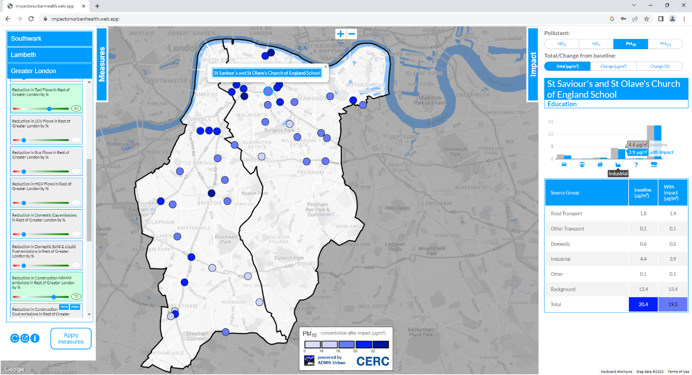
(Click to enlarge)
Impact on Urban Health (IoUH) and Southwark and Lambeth Councils have a shared ambition to reduce the harmful impact air pollution has on people's health, particularly those most at risk. With this objective in mind, they jointly commissioned CERC to develop a digital air pollution impact tool to model the impacts of changes to air pollution sources, and the adoption of mitigation measures, on levels of air pollution exposure. The tool is potentially scalable to all London local authorities, and is a 'ground-breaking' example for city authorities around the world, as are CERC's Breathe London and airTEXT services.
CERC selected sensitive locations in Lambeth and Southwark according to the risk from air pollution exposure and focusing on areas of deprivation, according to Indices of Multiple Deprivation (IMD) values. The team used ADMS-Urban to calculate concentrations of NO2, PM10 and PM2.5 at these locations and calculated the contribution of different source groups at each location.
Project results allowed the identification of measures that affect exposure to air pollution at each location, such as changes in traffic movements, emissions performance of vehicles, or the use of different fuels for heating and cooking. The impact of each measure on exposure to the pollutants was modelled at each sensitive receptor site. CERC's web-based interactive tool encapsulates the model results and allows the user to view the impact of different combinations of mitigation measures.
The health impacts of mitigation measures were assessed using the modelled concentrations in combination with population, age and health data. Project results and the methodology used for the work can be found in our report. In 2025, CERC will review the model, checking usability and updating inputs where new data has become available.
Breathe London: web platform for world-leading air quality sensor network

(Click to enlarge)
The Breathe London project has deployed 100 state-of-the-art fixed air quality sensor pods on lampposts and buildings close to known air quality hotspots and sensitive locations such as schools and nurseries. The data these monitors collect from across the capital is providing an unprecedented level of detail about London's air quality and delivering new insight into the sources of pollution.
CERC developed the web platform that provides the data, maps and visualisations for the Breathe London website. The platform uses the Google Cloud, which enables user-friendly performance when querying these large datasets to provide graphs and visualisations, and ensures the replicability and scalability of the platform to other cities around the world. The platform is capable of ingesting data automatically in near-real-time from Breathe London's AQMesh sensors and also other monitor networks such as the London Air Quality Network. The platform is open-source and so it is freely replicable by other cities around the world that wish to build their own platform.
The Breathe London network was launched by the Mayor of London, Sadiq Khan, on 15 January 2019. Breathe London is a consortium led by the Environmental Defense Fund, including CERC, Air Monitors, University of Cambridge, National Physical Laboratory and Google Earth Outreach, who have equipped two of their iconic Street View cars with air quality sensors.
QCumber-EnvHealth: a new integrated decision-making tool for urban health and policy evaluation
In the QCumber-EnvHealth project CERC have created a unique platform for health policy and decision-making relating to inequality. The initial public platform for Glasgow is based on integration of existing open data (for instance from Glasgow Data Launchpad and Scottish Neighbourhood Statistics) and new health-related social behaviour data. The air pollution model ADMS-Urban has been set up for Glasgow and linked to these datasets.
Learn more
- Access the public Glasgow platform
- Learn more about the QCumber-EnvHealth project
- Reports (pdf) and presentations (pdf) from the two QCumber-EnvHealth stakeholder workshops (27 September 2017, 13 June 2016)
CARBONES web platform for carbon cycle data

(Click to enlarge)
CERC created an advanced web platform (www.carbones.eu) for displaying carbon cycle data from the EU FP7 project CARBONES. The science component of the project produced a global reanalysis of carbon fluxes and pools over a twenty-year period, which can be used by climate scientists to improve their models. The web platform is entirely based on free and open-source components, and provides the scientific results as highly-interactive maps and graphs. The project uses open data standards such as INSPIRE and netCDF CF (Climate and Forecast conventions). The geoportal has great potential for reuse in other projects, in the carbon cycle and beyond, in particular anywhere where CFnetCDF is used (in atmospheric science, earth science and oceanography). A relatively small amount of development would be needed to adapt it for other projects.

(Click to enlarge)
The web platform offers the following advanced features in the maps (visit www.carbones.eu and choose Product-Maps):
- Animations playing directly in the map interface
- User-editable colour scales for the raster data
- Export of animations and maps to KML for use in Google Earth
- PDF creation
- INSPIRE-compliant view service (WMS)
- Presents other products for comparison with CARBONES
- A fluid layout using the whole browser window, splitter controls to allow the user to resize page elements, and a tree control to select the variables with explanatory tooltip balloons
- Displays over one million map layers from 500GB of data.
- netCDF CF is an OGC standard. It is the preferred format for this data among the scientific users, so the portal is able to use the same data files created for the scientific end-users.
The following advanced features are present in the time series graphs of spatially-aggregated data (visit www.carbones.eu and choose Product-Time series):
- Slider control to allow interactive selection of the date range on display
- PDF creation
- Data download
Scientific users, including sponsors of web platforms from rival projects, have made very generous comments about the web platform, such as Congratulations on the great user interface, a dream an extraordinary way to deliver information and The mapping works flawlessly and is very useful. The time series are great and very intuitive.
For further information on the CARBONES web platform please contact us.
CERC would like to thank the CARBONES project co-ordinator Noveltis and the scientific co-ordinator LSCE. We acknowledge the support of the European Commission through the CARBONES (30-year re-analysis of CARBON fluxES and pools over Europe and the globe) project under the 7th Framework Program (contract number 242316).