
CERC — Environmental Software and Services

- Overview
- Atmospheric dispersion
- Atmospheric chemistry
- Urban air quality
- Regional to local air quality modelling
- Vehicles and roads
- Aviation
- Emissions
- Urban heat island
- Atmospheric boundary layer
- Wind energy
- Hazardous releases
- Inverse dispersion modelling
- Net Zero
- Model evaluation
- Smart cities
- Web platforms
- Older projects
- CERC co-author publications
- CERC software publications
- Presentations
Atmospheric boundary layer
Quick links: Wind shear Urban canopy Dispersion around buildings FLOWSTAR for roughness Offshore boundary layer Planetary boundary layer
The atmospheric boundary layer (also referred to as the planetary boundary layer) is the part of the atmosphere directly influenced by features on the surface of the earth; its depth can vary from tens of metres to a few kilometres. Understanding the structure of the atmospheric boundary layer is not only a fundamental part of atmospheric dispersion modelling but is also necessary in order to investigate wind energy opportunities, local climate effects and situations where flow and turbulence events impact on human activities, for instance at airports.
Spatially homogeneous, vertically varying profiles of meteorological parameters can be defined when the earths surface is relatively uniform in terms of terrain elevation and surface protrusions, as described by the boundary layer structure used in ADMS for flat terrain conditions. In hilly and forested regions, the wind and turbulence fields are more complex and spatially inhomogeneous; it is difficult to derive formulae to describe the flow and models are commonly used to calculate variations within the atmospheric boundary layer. Flow models are applied at different scales, for instance the high-resolution FLOWSTAR-Energy model is used for wind farm planning and assessment, whereas mesoscale numerical weather prediction models such as WRF are linked to Eulerian chemical transport models for regional atmospheric dispersion modelling applications.
Buildings and other man-made structures impact on flow at the local scale. These local flow variations significantly impact on air quality: at industrial sites, buildings downwash may cause plume grounding; in urban areas, high building densities reduce wind speeds and increase turbulent intensities within the urban canopy, which impacts on dispersion of emissions from traffic and other sources; and within street canyons, the combination of low wind speeds, flow recirculation and channelling can lead to high pollutant concentrations.
In addition to building morphology impacting on wind flow in urban areas, building materials and the lack of surface water alter the local climate causing the urban heat island effect. This can be modelled both at the city and neighbourhood scale using ADMS-Urban.
Modelling wind shear at Hong Kong International Airport using FLOWSTAR-Energy


Significant wind shear at Hong Kong International Airport, situated on Lantau Island, can occur as a result of wind flow over mountain ridges to the south of the airport. Severe wind shear events can cause aircraft to abort their landings, leading to disruption to passengers, in addition to increased operator costs and in-flight risk.
CERC are working with a group at the Hong Kong Observatory (HKO) with the aim of developing a system that is able to predict such wind events. CERCs FLOWSTAR-Energy model is being used to simulate the complex airflow over Lantau Island using observed radiosonde and wind profiler data as input. Sensitivity studies have replicated the large variations in wind speed, wind shear and wind direction occurring on the approach path when the upwind flow from the southeast is stably stratified above the boundary layer with a significant temperature inversion no more than a few hundred metres above the mountain ridges. Published results include model evaluation using data from HKOs network of ground-based monitors on islands to the southeast of the airport and Plan Position Indicator (PPI) scans from the LIDAR instrumentation at the airport.
This work suggests that near real-time application of the FLOWSTAR-Energy model and simultaneous monitoring with remote and in situ instruments will be able to predict these extreme flow events and hence provide advance warnings.
Learn more
- Stocker J, Carruthers D, Johnson K, Hunt J and Chan PW,2016:Optimized use of real-time vertical-profile wind data and fast modelling for prediction of airflow over complex terrain.Meteorological Applications, vol. 23, issue 2, April 2016, pp. 182-190, DOI: 10.1002/met.1544. Article online
- Carruthers D, Ellis A, Hunt J and Chan PW,2014:Modelling of wind shear downwind of mountain ridges at Hong Kong International Airport.Meteorological Applications, vol. 21, issue 1, January 2014, pp. 94–104, DOI: 10.1002/met.1350Article online
Urban canopy flow
Flow and dispersion in urban areas is affected by the presence of buildings, with wind speeds reduced and turbulence intensities increased below the average building height. The variation of building characteristics across an urban area creates a corresponding variation of flow characteristics. CERC developed the urban canopy flow option in the ADMS family of models to calculate this variation of flow based on gridded building data under a project funded by the Hong Kong Environmental Protection Department. It has been tested as part of dispersion model evaluations in London and Hong Kong.
London buildings data has been processed by CERC for input to the urban canopy option and is available as a free download here. The data were produced for the research project Coupled Urban and Regional processes: Effects on AIR quality (CureAir). CureAir is a collaboration between CERC, the universities of Edinburgh and Leeds, and the Centre for Ecology & Hydrology. The data were published with a paper by CERC and can be re-used without restriction. Urban canopy flow data for other domains can be calculated from 3D buildings data using the CERC Mapper's Canyon and Canopy tool.
Dispersion around buildings: comparison with wind tunnel and CFD
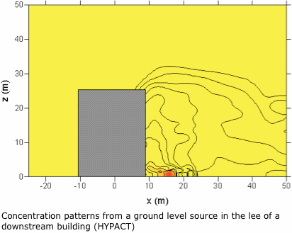

Mitsubishi Heavy Industries Ltd (MHI) of Japan contracted CERC to assist in evaluating the CFD dispersion model HYPACT, interpreting results, and improving the model for the case of an accidental release in the vicinity of a single block building. The flow field around the building was calculated using the RAMS model.
HYPACT was evaluated against wind tunnel data and results were interpreted by using the COST-732 Model Evaluation Guidelines. Based on the results and performance achieved, CERC used their expertise to suggest improvements to the model.
In the comparison exercise, ADMS 4 was used to model the concentration from an area source placed in the lee of an isolated building, at ground level. Mean concentration results from ADMS 4 were compared against wind tunnel and HYPACT, showing satisfactory agreement.
Mesoscale modification of FLOWSTAR for sharp changes in surface roughness
Coastal meteorology is complex and of great practical importance, for instance for coastal wind farms and flooding predictions. In 2005 and 2006 CERC developed modelling tools to compute wind flows in coastal regions, where there are sharp changes in surface roughness. These tools extend CERC's FLOWSTAR model and produce results in high spatial resolution on a standard Windows PC. The work built on the research of CERC's technical director Professor Julian Hunt.
The mathematical model is a general linearized shallow-layer perturbation model, where the approximately neutral lower layer of thickness h0 is situated below a stable upper layer (i.e. an inversion with temperature change ΔT), is developed for steady, mesoscale atmospheric flows over low-lying topography whose height is less than h0. With the Coriolis parameter f, sharp changes in surface conditions (surface roughness, terrain elevation, heat flux) are modelled as a distributed body force through the lower layer. The Froude number of this layer is small.
The project was supported by Mitsubishi Heavy Industries and Kyoto University.
Learn more
- Hunt JCR, Orr A, Rottman JW, and Capon R,2004:Coriolis effects in mesoscale flows with sharp changes in surface conditions.Q. J. R. Meteorol. Soc., 130:2703-2731. Article online
- Orr A, Hunt JCR, Capon R, Sommeria J, Cresswell D, and Owinoh A,2005:Coriolis effects on wind jets and cloudiness along coasts.R. Meteorol. Soc. Weather, 60:10:291-299. Article online
Parameterisation of the atmospheric boundary layer for offshore dispersion
Under a contract with the UK Department for Trade & Industry, CERC developed a marine boundary layer scheme for calculating surface roughness and heat fluxes over the sea that can be used, for instance, for dispersion modelling of stacks on oil extraction platforms. The scheme is only applicable when all sources and receptors are at sea.
The scheme has been incorporated into ADMS 6 as the marine boundary layer option which is described in Section 9.9 of the ADMS 6 User Guide (see the User guide page).
Supported by the UK Department of Trade and Industry (DTI).
Learn more
- Development of boundary layer profiles report(.pdf, 1MB)
Assessment of modelled and measured planetary boundary layer structure
The structure of the planetary boundary layer over Southeast England was assessed by applying different boundary layer schemes in the WRF mesoscale meteorological model at 3 km resolution and comparing to LIDAR measurements. There are significant differences (>20%) in the planetary boundary layer heights predicted using the different boundary layer schemes, in particular between non-local and local mixing schemes. This work was carried out in collaboration with researchers from the Hong Kong University of Science and Technology and the University of Reading and was published in 2013.