
CERC — Environmental Software and Services
- Overview
- Air pollution modelling
- ADMS 6
- ADMS-Roads (Extra)
- ADMS-Urban
- MAQS
- ADMS-Airport
- ADMS-Screen
- Feature comparison
- Emissions management
- EMIT
- Wind energy and airflow
- FLOWSTAR-Energy
- Accidental releases
- GASTAR
- LSMS
- ADMS-Puff
- ADMS-STAR
- Managing model runs
- Run Manager
- Model evaluation
- Model Evaluation Toolkit
- Meteorological data processing
- WRFtoMet
- Related Documentation
- User guides
- Technical specifications
- Model validation
- Newsletters
- Publications
- CERC co-author publications
- CERC software publications
- Presentations
- Other information
- Traffic emissions
- Prices
- Free demo
- Visualisation tools
- Current software versions
- System requirements


ADMS-Airport
World leading software for air quality management for airports
What is ADMS-Airport?
ADMS-Airport is a comprehensive modelling tool for air quality management of airports. It has many of the features of the ADMS-Urban model and includes allowance for all relevant emission sources at airports and utilises algorithms designed specifically to model dispersion from aircraft engines.
Who uses ADMS-Airport?
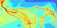
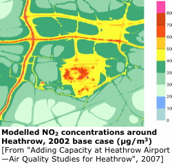
ADMS-Airport has been used to model air quality at London's Heathrow airport for the 2002 base case and future year scenarios as part of the Department for Transport's (DfT) Project for Sustainable Development of Heathrow (PSDH)—Adding Capacity at Heathrow.
This followed the PSDH Model Inter-comparison Study and the recommendations of the DfT's expert panel on modelling which was in 'full agreement in the recommendation of the CERC model ADMS-Airport for future modelling work at Heathrow'. ADMS-Airport continues to be used for air quality assessments at Heathrow airport (see the Heathrow Air Quality Strategy 2011).
London Gatwick Airport has used ADMS-Airport for dispersion modelling in all its recent assessment studies (see Gatwick Airport’s July 2014 submission to the Airports Commission).
ADMS-Airport is also one of the approved models for the International Civil Aviation Organisation, Committee on Aviation Environmental Protection (ICAO CAEP), Models and Databases Group. The approved models create projections at all major airports worldwide that are used by the ICAO Assembly as the basis for decision making on environmental matters.
The ICAO Airport Air Quality Manual gives simple, advanced and sophisticated approaches for dispersion modelling in the vicinity of airports. ADMS-Airport is listed as a typical model used in the advanced and sophisticated approaches.
Why use ADMS-Airport?
ADMS-Airport incorporates all the features of ADMS-Urban plus it is able to incorporate sources specific to an airport. ADMS-Airport is able to take into account the whole range of relevant emission sources: aircraft traffic, auxiliary power units, ground support equipment, road traffic, industrial, commercial, domestic and other less well-defined sources.
ADMS-Airport and EMIT (CERC's Emissions Inventory Toolkit) have been developed with a number of features to simplify the modelling process and help users. For example:
| Visualisation | ADMS-Airport is supplied with the Mapper and has links to Surfer contour plotting package. The Mapper can be used to enter and display input data and display output, usually as colour contour plots. |
|---|---|
| Emissions inventory | Source and emissions data can be imported from text files created by the user or exported from EMIT. EMIT contains current and future emission factors including those for vehicles, industrial processes and fuel consumption. |
| Emission factors (in EMIT) |
EMIT can be used to calculate emissions from turboprops, turbofans and piston engines, APUs and GSE. Road emissions can be calculated from traffic flows and speeds. |
| Source-oriented gridding | ADMS-Airport includes a source-oriented gridding option which places extra output points in and adjacent to aircraft jet sources and road sources to give excellent spatial resolution in areas of particular interest. |
| User-defined outputs | The user defines the pollutant and averaging time which may be an annual average or a shorter period, and also which percentiles and exceedence values to calculate, and whether a rolling average is required or not. The output options are designed to be flexible to cater for the variety of air quality limits which can vary from country to country and over time. |
ADMS jet module
ADMS-Airport makes use of the ADMS jet model to calculate the impact of aircraft exhausts. The jet model calculates an integral solution to the equations of conservation of mass, momentum, heat and species, capturing the effect of the movement of the jet engine source in reducing the effective buoyancy of the exhaust. This is particularly important in capturing the near-field dispersion from the high momentum, buoyant take-off ground roll sources.
Hourly profiles
To model the airport's flight schedule in detail users can construct annual hourly profiles. These detailed schedules can also be used for detailed modelling of non-airport sources, such as the effect of school terms and public holidays on road traffic. For less detailed time dependent modelling ADMS-Airport allows diurnal and monthly profiles plus wind direction dependence for any source.