
CERC — Environmental Software and Services

CERC news
< Previous1234567891011121314151617181920Next >
4 Feb 2021Webinar: how can data supercharge efforts to lower air pollution in cities?
Public webinar Tuesday 9 Feb 16:00-17:00 GMT
The evidence is clear: air pollution has severe health impacts around the world. New technology is allowing us to map pollution street-by-street, identify hotspots and share unprecedented amounts of air quality data. The Breathe London pilot was an ambitious two-year project that measured pollution across the city using 100 lower-cost sensor 'pods' and specially-equipped Google Street View cars, serving as a world-leading example of how emerging technology can help accelerate clean air action. CERC was a partner in the pilot project, providing the public project data platform and ADMS-Urban modelled data and analysis.
Join this webinar for a discussion of key lessons from the pilot project and the launch of the Breathe London Blueprint, as well as how new efforts to leverage air quality data are shining a light on pollution at a scale and scope across the globe like never before.
Amy Stidworthy from CERC will discuss how the ADMS-Urban model was used in the pilot project to produce detailed, location-specific information on pollution sources and to assess the impact of potential future policies on reducing air pollution in London.
Also featuring:
- Matt Whitney from Clean Air Fund, a philanthropic initiative tackling air pollution around the world
- Elizabeth Fonseca from Environmental Defense Fund Europe, which managed the Breathe London pilot project
- Jeremy Taub from OpenAQ, a platform that is fighting air inequality with open data
See the LinkedIn event page for more information and to register for the webinar.
25 Jan 20212020 ADMS User Group Meetings – recordings of CERC presentations are available to view
Following last year's ADMS User Group Meetings, which took place online on 18 and 19 November, recordings of the CERC presentations are now available to view in the CERC website User Area, alongside these are PDF copies of all the presentations. Model users with a valid support contract, including all annual licence holders, are entitled to register for password-protected access to the User Area. To register, or to be reminded of your password, click here.
11 Dec 2020Highways England sponsor ADMS-Roads elevated roads development
CERC have enhanced ADMS-Roads to address the air pollution from elevated roads within the Highways England Strategic Roads Network (SRN). ADMS-Roads is the most widely used air dispersion modelling tool for predicting concentrations of nitrogen dioxide (NO2) and other pollutants near roads on the SRN. This project will have far-reaching influence as ADMS-Roads becomes the first commonly-used tool to include the significant effects of wind flow around flyovers on pollution impact for local populations.
Highways England, in partnership with Innovate UK, funded these scientific developments through an SBRI competition to support innovations to tackle air quality around the country's motorways and major A roads. Chris Hogan, Air Quality Designated Fund Programme Manager at Highways England, said "This very successful project exemplifies a great benefit of the innovation competition, which is that it enables our technical specialists to engage directly with external experts to create solutions well adapted to our needs."
Full details of the project findings are given in the project report. Chris Hogan and CERC's Mark Jackson discussed the project and the SBRI initiative at a panel discussion in the Highways UK conference (view video).
CERC have provided Highways England with the new feature. CERC will also roll it out to all ADMS-Roads and ADMS-Urban users shortly.
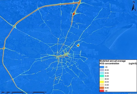
17 Nov 2020Regional-to-local scale air quality modelling for Ireland
The Irish Environmental Protection Agency has contracted CERC to undertake regional-to-local scale air quality modelling for Ireland in order to generate air quality maps for the whole country.
The project will couple regional and local scale models using CERC's ADMS-Urban Regional Model Link. This will combine regional modelling undertaken by the UK Centre for Ecology and Hydrology using the Weather Research and Forecasting (WRF) mesoscale meteorological model and the EMEP regional chemical transport model, with local modelling carried out using CERC's street-scale resolution air quality modelling tool, ADMS-Urban.
The modelling will use gridded MapEIRE emission data, compiled by the Department of Environmental Science at Aarhus University in Denmark, as input to both the local and regional scale modelling. CERC will also develop a local-scale emissions inventory for the five main cities in Ireland (Dublin, Cork, Limerick, Waterford and Galway) and Ireland's major road network using EMIT.
This project builds on the success of CERC's previous Dublin air quality modelling work for the EPA, which was widely reported by local and national media. CERC will also provide training in air pollution mitigation strategy assessment for the EPA air quality team, allowing them to take the work forward.
The figure shows 2017 annual average NO2 concentrations modelled using ADMS-Urban as part of the earlier study.
22 Oct 2020ADMS User Group Meetings, Online, 18-19 November 2020: Draft agendas now available
The draft agendas for this year's ADMS User Group Meetings are now available. Tickets are available to order through Eventbrite until 23:30 on Sunday 15th November and cover the full two-day event. Organisations with a valid software support contract are entitled to one or more tickets free of charge depending on the type of licence held. Meeting connection details will be sent to registered participants before the event.
You can also follow CERC news on Facebook, X, LinkedIn and by RSS.
< Previous1234567891011121314151617181920Next >