
CERC — Environmental Software and Services
- Overview
- Choosing a model
- Air pollution modelling
- ADMS 6
- ADMS-Roads (Extra)
- ADMS-Urban
- MAQS
- ADMS-Airport
- ADMS-Screen
- Feature comparison
- Emissions management
- EMIT
- Wind energy and airflow
- FLOWSTAR-Energy
- Accidental releases
- GASTAR
- LSMS
- ADMS-Puff
- ADMS-STAR
- Managing model runs
- Run Manager
- Model evaluation
- Model Evaluation Toolkit
- Meteorological data processing
- WRFtoMet
- Related Documentation
- User guides
- Technical specifications
- Model validation
- Newsletters
- Publications
- CERC co-author publications
- CERC software publications
- Presentations
- Other information
- Traffic emissions
- Prices
- Free demo
- Visualisation tools
- Current software versions
- System requirements
Choosing a model
Quick links:Industrial permitting and planning Air quality management EU Air Quality Directive 2024/2881 Sensitive habitats assessment Planning and development control Accidental releases and abnormal emissions Agriculture and waste Urban environment and climate change Wind energy and airflow
CERC's suite of ADMS models and other software has a far-reaching user base, assisting users across the globe to model scenarios in a wide range of sectors and industries, and supporting numerous types of assessment and research. Here some of the many applications of CERC's software are described, and guidance is given on choosing which CERC software product you should use for each application.
All CERC software products have an accessible user interface that allows for flexible modelling input, and multiple outputs needed for comparison against environmental and safety standards. For a detailed comparison of the features of the ADMS models, please see Feature comparison.
Assessment types
Industrial permitting and planning
All types of industry that release emissions to air can require, or benefit from, detailed dispersion modelling. ADMS is used to model a wide range of sites, such as data centres, energy centres, oil and gas rigs and refineries, manufacturing plants, fossil fuel and nuclear power plants, crematoria and hospitals.
These industries generally require the regulation of pollutant emissions from combustion stacks and other process emissions that emit to air via stacks, vents, flares or as fugitive sources. The dispersion modelling associated with assessment and regulation of the air quality impacts of these sources can be achieved using the ADMS 6, ADMS-Urban, ADMS-Roads and ADMS-Screen models.
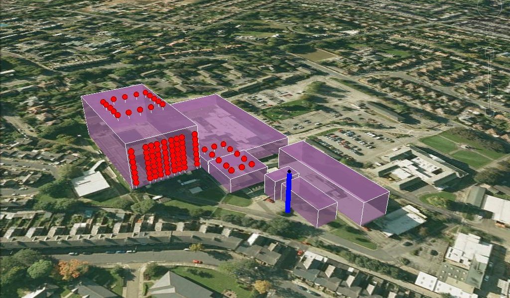
Source, buildings and receptors for an energy centre at a hospital, modelled using ADMS 6
For industrial modelling, the most recommended model is ADMS 6, which has additional modules facilitating the modelling of instantaneous releases, visible plumes, radioactivity, and amine-based carbon capture. ADMS-Urban and ADMS-Roads can also be applied to most industrial source modelling scenarios, and are particularly useful where vehicle emissions are involved.
Examples of assessments where ADMS is widely used include:
- Environmental Statement for a planning application
- Environmental Permit application or permit variation
- Environmental Impact Assessment (EIA)
- Stack height assessment
- Habitats assessments, for example for Habitats Regulations and Habitats Directive
- Front-End Loading (FEL) planning process, involving Front-End Engineering Design phase (Pre-FEED and FEED)
- Further detailed modelling after a screening assessment, for example the H1 risk assessment tool.
Air quality management
Local, regional and national authorities and agencies around the world use ADMS-Urban in assessment, analysis and mitigation of air quality issues. These include assessing consequences of proposed air quality improvement measures such as the introduction of Low Emission Zones or Low Traffic Neighbourhoods, or to carry out scenario modelling assessing the relative impacts of implementing different policy measures. The ability to model dispersion of emissions from roads (including flyovers and tunnels), industry, and diffuse gridded emissions such as domestic heating over a wide area, allows for flexible and detailed scenario modelling. ADMS-Urban also models the influence of the urban and natural environment on dispersion, including modules for street canyons, the urban canopy and complex terrain.
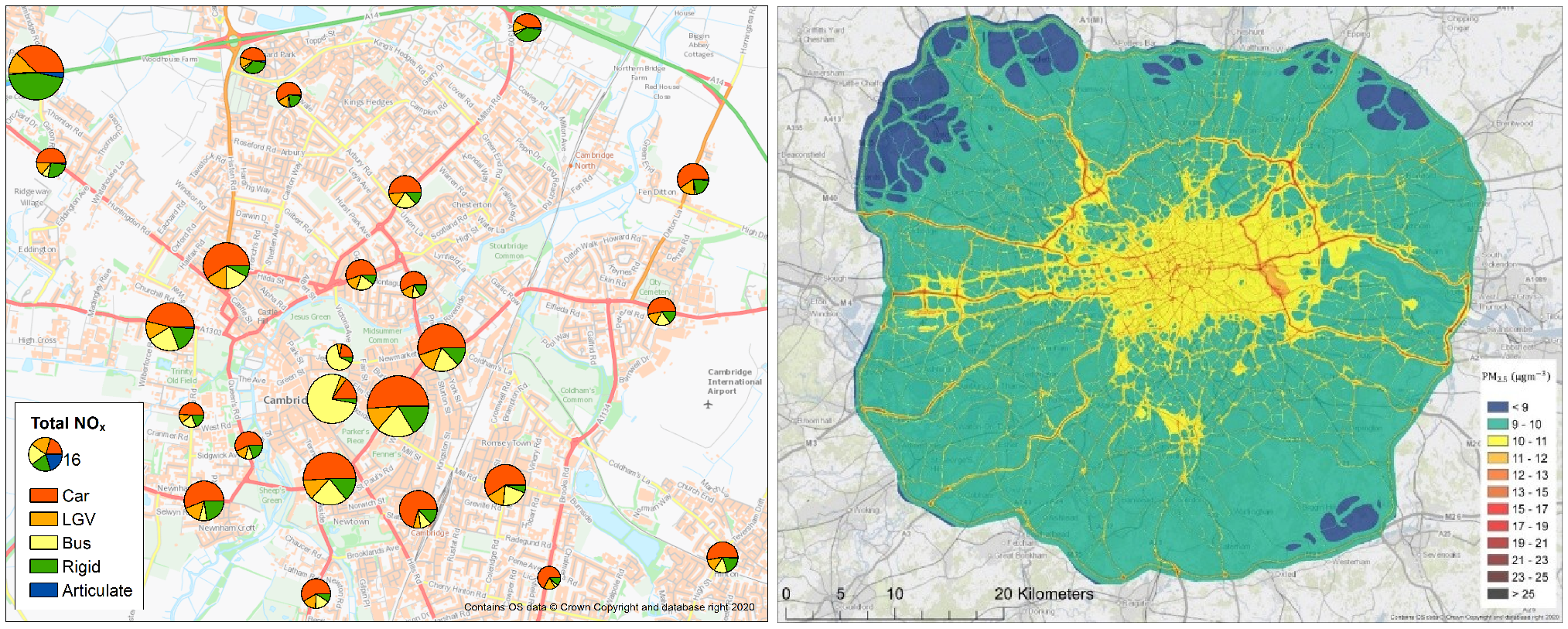
Annual average road contribution to NOx concentrations by vehicle type, modelled using ADMS-Urban (left) and annual average concentrations of PM2.5 in London in 2019, modelled using ADMS-Urban (right)
ADMS-Urban is suitable for modelling areas up to city-scale. For modelling on a larger regional or national scale, ADMS-Urban can be combined with MAQS to offer accurate representation of dispersion and chemistry over large spatial and temporal scales, whilst maintaining high resolution output for detailed assessment.
ADMS-Airport is ideal for the assessment of the air quality impact of aircraft and airports. In addition to all of the features of ADMS-Urban, ADMS-Airport provides detailed modelling of aircraft emissions associated with the Landing Take Off cycle, making it a comprehensive tool for modelling all emissions associated with an airport and its local area. ADMS-Airport is approved by the UK Department for Transport (DfT) and the International Civil Aviation Organisation Committee on Aviation Environmental Protection (ICAO CAEP).
For small-scale projects, such as assessing individual road systems, or modelling a combination of a few industrial and road sources, ADMS-Roads is an ideal model. ADMS-Roads includes all the features of ADMS-Urban except the ability to model diffuse gridded emissions and coastline effects, and is designed for smaller numbers of pollution sources.
More information about the differences between the ADMS models can be found on the Feature comparison page.
Pre-calculated road emissions data can be imported to ADMS-Airport, ADMS-Urban and ADMS-Roads. In addition, and of particular use to UK users, these models can calculate road emissions directly from traffic flow data using Defra’s Emission Factor Toolkit (EFT) fleet and emissions factors.
To compile emissions for a large number of sources and easily edit emissions for scenario modelling, CERC’s emissions inventory tool (EMIT) allows simple, fast calculation and analysis. Output from EMIT is directly compatible for input to ADMS, spreadsheet editors, and Geographic Information Systems (GIS).
Examples of assessments for which ADMS-Urban, ADMS-Roads and ADMS-Airport are ideal model choices include:
- Policy analyses, for example under the Convention on Long-Range Transboundary Air Pollution (CLRTAP)
- UK Local Air Quality Management (LAQM) annual reporting, for example for Local Plans, Area Action Plans and Annual Status Reports (ASR)
- Designation and assessment of air quality focus areas, for example Low Emission Zones (LEZs), Air Quality Management Areas (AQMAs) and Smoke Control Areas
- Compliance with national and regional legislation including the EU Air Quality Directive 2024 and the UK Air Quality Standards Regulations 2010
- Habitats assessments, for example for Habitats Regulations and Habitats Directive
EU Air Quality Directive 2024/2881
The revised European Union (EU) Ambient Air Quality Directive (AAQD) 2024/2881 is required to be transposed into national law by all Member States by 11 December 2026. It establishes strict air quality standards and strengthens the legislative framework for air quality assessment and management in the EU. A key feature of the Directive is the enhanced role of air quality modelling, which is recognised as an essential tool for compliance assessment, the determination of source apportionment and the preparation of effective air quality plans.
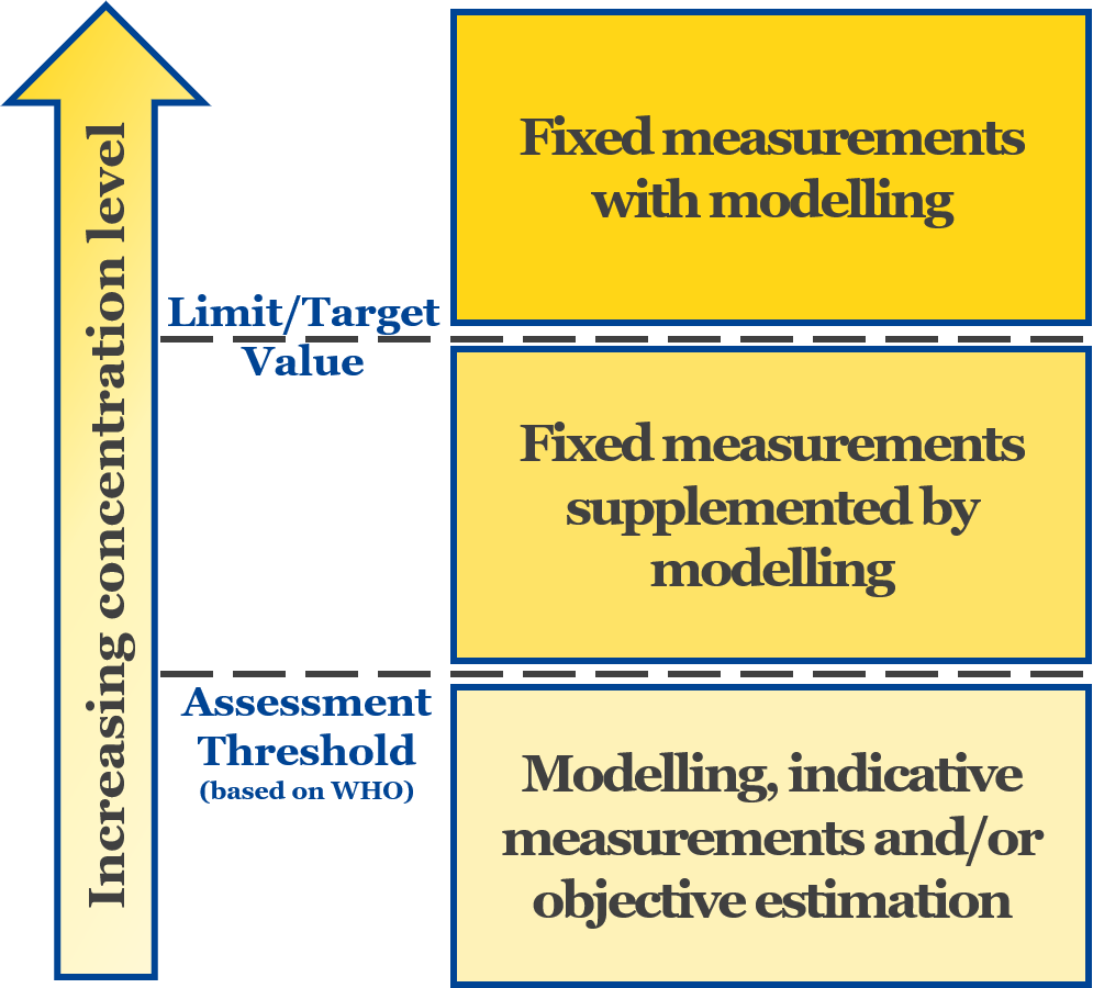
Diagram summarising the assessment regimes defined in Directive (EU) 2024/2881
The assessment of multiple air quality limit values and target values, each defined over different averaging periods, combined with the different spatial scales across the geographical extents of EU Member States, presents significant technical challenges. In this context, the Multi-Model Air Quality System (MAQS) provides a powerful and practical solution. By coupling the street-scale ADMS-Urban model with regional-scale air quality models, MAQS enables pollutant concentrations to be assessed consistently from local hotspots to national and transboundary scales. The system is specifically designed to minimise the double counting of emissions and to ensure that physical and chemical processes are represented appropriately across all relevant spatial and temporal scales.
This document provides information on the requirements for air quality modelling under AAQD 2024/2881 and describes how ADMS-Urban and MAQS are suitable for this application.
Sensitive habitats assessment
Habitats assessments often form part of a wider assessment of air pollutants; for example, as part of a permit application or Environmental Impact Assessment (EIA). Consideration of impacts at habitats can also be required as a standalone assessment, such as for designated conservation sites in close proximity to major roads. For industrial assessments, users will typically use ADMS 6, although if road sources are of concern then ADMS-Roads has the required features.
ADMS can be used to calculate pollutant concentrations and deposition rates for the protection of vegetation and ecosystems, for example as part of a UK Habitats Regulations Assessment (HRA).
Planning and development control
Software users working in planning and development are typically regulators, property developers, planning experts and consultants, supporting infrastructure, residential and commercial projects.
The model used depends on the source types under consideration, and can cover a wide range of assessments, from a single boiler flue (where ADMS 6 is appropriate) to a major traffic scheme (where ADMS-Urban or ADMS-Roads can be used) or changes to the operation of an airport (where ADMS-Airport is appropriate).
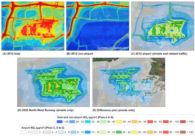
Annual average NO2 concentrations for different sources and scenarios at London Heathrow Airport, modelled using ADMS-Airport
Examples of planning and development control assessments that can use ADMS modelling include:
- Part of the Environmental Statement for an Environmental Impact Assessment (EIA) or a planning application
- Support planning/permitting for national and transboundary infrastructure projects, for example Development Consent Order (DCO) for Nationally Significant Infrastructure Projects (NSIPs) or Projects of Mutual Interest/Projects of Common Interest (PMI/PCI)
- Habitats assessments, for example for Habitats Regulations and Habitats Directive.
Accidental releases and abnormal emissions
The modelling of hazardous releases, such as a liquid spill, catastrophic failure of a tank or rupture of a pipeline, is required both for assessment of potential emergency situations or for modelling real events. Toxic or flammable substances, such as ammonia, chlorine, hydrogen and refrigerants, often need to be considered.
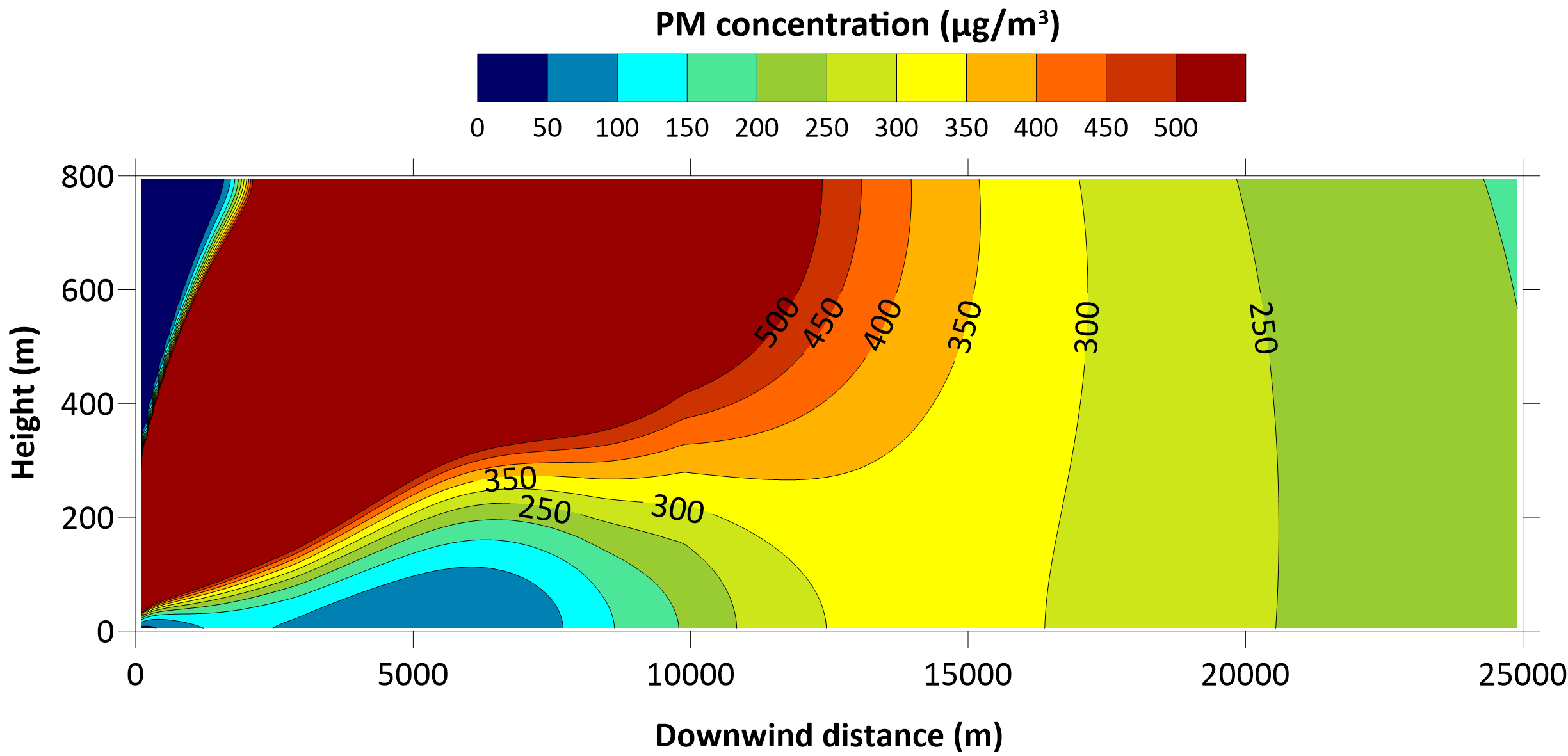
Vertical cross section of particulate matter concentrations from a crude oil tank fire, modelled using ADMS 6
Depending on the nature of the release, CERC offer various suitable models. ADMS 6 is the most flexible and commonly applicable model whilst, specifically for dense gases, CERC offer the GASTAR model. If the initial source of the release is a liquid spill, then CERC's Liquid Spill Modelling System (LSMS) can assist in defining source parameters.
ADMS 6 and GASTAR can include the influence of obstacles/buildings, slopes and directional releases. Model outputs can be compared with a range of threshold values, such as toxic loads (doses), exposure limits and flammability levels.
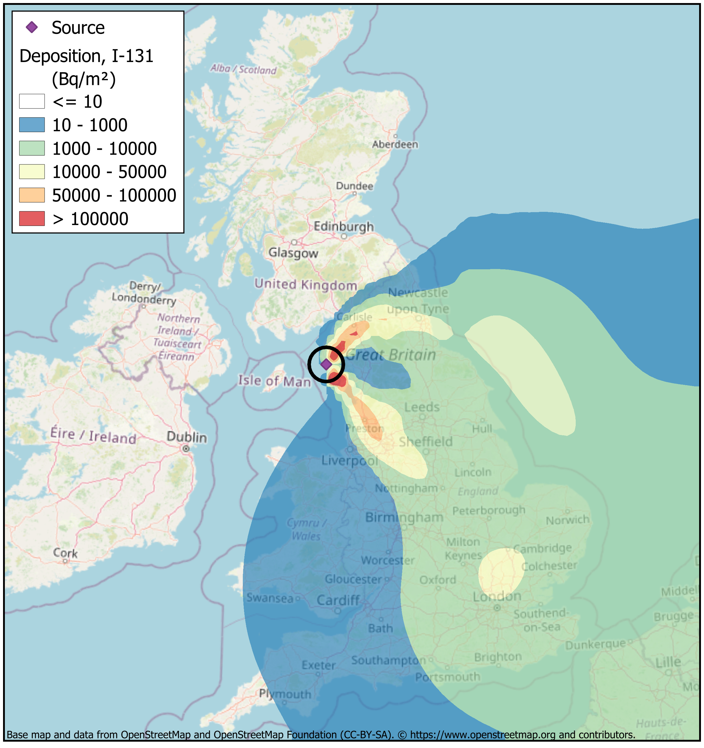
Contour map of total I-131 deposition from the 1957 Windscale fire, modelled using ADMS-STAR, with the extent of the imposed milk ban shown by the black circle
ADMS 6 is also particularly suitable to assess the likely impacts of smoke plumes, such as those from waste or warehouse fires, battery fires at Battery Energy Storage System (BESS) sites, or emergency flaring, benefiting from the model’s advanced integral plume rise module.
For some large scale releases, such as radioactive or explosive releases, ADMS-STAR (or ADMS-Puff for dense gases) may be more applicable as they use a Lagrangian puff approach with spatially and temporally varying meteorological conditions.
Examples of accidental and abnormal release applications where ADMS and GASTAR modelling may be beneficial include:
- Assessments for control of industrial accidents, for example under the Seveso III Directive and Control of Major Accident Hazards (COMAH, for UK Health and Safety Executive (HSE))
- Human Health Risk Assessment (HHRA)/HHRAP
- Environmental risk assessments for accidental and abnormal releases
- Consequence modelling
- Emergency response planning
- Process safety management.
Agriculture and waste
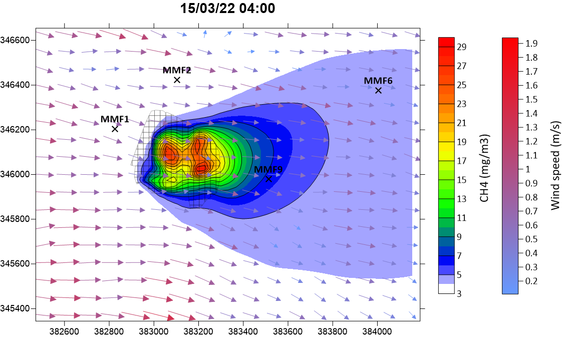
Contour plot of methane (CH4) concentrations from a landfill site and local wind vectors due to terrain, modelled using ADMS 6
Assessment of agriculture and waste industries is often associated with impacts of odour, from sources such as those from intensive farming, landfill and waste water treatment. Detailed modelling can be required for planning and permitting, or as a result of local complaints.
Both ADMS 6 and ADMS-Roads include the option to model output in terms of odour units. ADMS 6 is particularly suited to the modelling of odour, with additional options such as including the impact of short-term fluctuations.
Beyond odour, specific pollutants such as methane, ammonia, or hydrogen sulphide can be a particular concern at agricultural or waste processing facilities, and are suitable for modelling using ADMS software.
ADMS can also be applied using an iterative approach to aid in inverse modelling studies, or as part of developed framework methodologies. This is particularly useful where there is uncertainty in the emissions, in cases where there are local concentration measurements; for example, with fugitive emissions of methane from a landfill site. See CERC's inverse dispersion modelling page for further information on applying these modelling approaches.
Examples of air quality assessments relating to agricultural and waste industries that make use of ADMS modelling include:
- Part of the Environmental Statement for a planning application
- Environmental Permit application or permit variation
- For further detailed modelling after a screening assessment, for example using SCAIL.
Urban environment and climate change
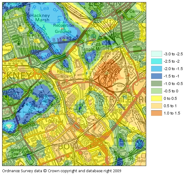
Contour map of local temperature variations (relative to ambient, in degrees C) on a late summer afternoon, modelled using the ADMS-Urban Temperature and Humidity model
With climate change and rapid urbanisation, the influence of the built environment on local temperature and humidity levels is of increasing interest. Policy makers and planners must consider adaptation strategies for urban heat islands that develop during the summer months and affect the physical wellbeing of residents of cities worldwide.
For tackling these problems, CERC's ADMS-Urban Temperature and Humidity model (an extension to ADMS-Urban) can help investigate the impact of urban land use and morphology, and anthropogenic activities, on local temperatures.
This model is used internationally in cities, with modelled heat maps being used as input to Climate Risk and Vulnerability Assessments (CRVA) and health modelling.
The influence of local climate change adaptation measures, such as green infrastructure, on the dispersion of pollution in urban areas can be considered at different scales within ADMS-Urban. Examples of modelling include assessing changes in tree cover, which alter urban ventilation corridors and hence pollutant dispersion, and quantifying the impact of vegetation barriers planted between road traffic and housing.
Wind energy and airflow
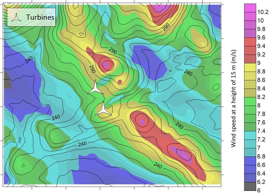
Wind speed map (m/s) overlaid with terrain height contours (m), showing the effect of two wind turbines, with hub height 55 m, on local wind speed for a south-westerly upstream wind, modelled using FLOWSTAR-ENERGY
The foundation of the ADMS models is as an atmospheric boundary layer model, representing airflow and turbulence in the lower atmosphere. Beyond modelling the dispersion of pollutants in the air, ADMS is well suited to providing outputs relevant to assessing the air flow itself.
Air flow quantification is particularly useful in the wind energy sector, helping determine optimum placing of wind turbines to maximise energy yield and efficiency. CERC's FLOWSTAR-Energy model aids wind turbine placement, and predicted energy yield.
CERC's air pollution modelling software ADMS 6 models the influence of local obstacles/buildings and surface roughness/elevation on wind turbines, and the influence of wind turbines on dispersing plumes from nearby sources.
The models are suitable for both onshore and offshore sites.