
CERC — Environmental Software and Services
Coupled modelling using MAQS
Gridded regional-scale models provide an adequate representation of pollutant dispersion over large spatial domains, where concentration gradients are relatively low as a result of atmospheric mixing and transport processes (at longer times after release from the source). These models are particularly effective when long-range transport and detailed atmospheric chemistry are appropriately represented.
In contrast, under conditions characterised by steep concentration gradients (shortly after pollutant release), high-resolution dispersion models are required to accurately capture the spatial variability of pollutant concentrations, as well as the rapid chemical processes that occur, for instance, at roadside locations.
These models can be integrated within a single framework, although the coupling process is complex and requires careful treatment of emissions and chemistry across multiple spatial and temporal scales. CERC's Multi-Model Air Quality System (MAQS) addresses this challenge by coupling the street-scale ADMS-Urban model with regional-scale models. The system avoids double counting of emissions while ensuring that chemical transformations are consistently represented across all scales. The modelling framework is described in Hood et al., 2018, which forms the basis of the MAQS methodology and is summarised as:

The regional model calculations are performed offline, meaning that the nesting procedure is applied independently to each regional model grid cell rather than being carried out dynamically during the simulation. The local-scale model runs require meteorological fields and background pollutant concentrations derived from the regional model. Although the mixing time ΔT is theoretically dependent on factors such as grid resolution and meteorological conditions, a fixed value in the range of 1 to 2 hours is typically adopted in practical applications. To ensure consistency and accuracy of the coupled modelling system, it is essential that both the regional and local models use consistent emission values.
For further technical details of MAQS, please see the MAQS User Guide, which includes a Technical Summary (Section 8).
The figure, showing example pollution maps from EMEP4UK and MAQS for an example application (modelling of Ireland for the Irish Environmental Protection Agency (EPA)), highlights the smooth transition between the regional and local modelled concentrations. A range of scenarios in which MAQS has been applied are described here.
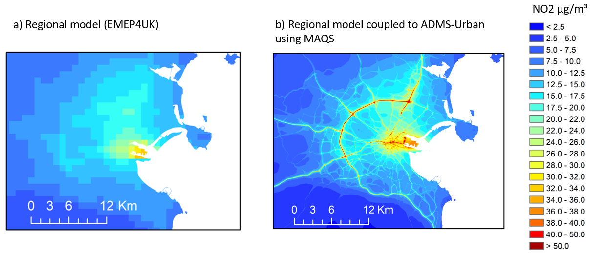
Map of modelled 2019 NO2 concentrations over the Dublin area using a) EMEP4UK and b) MAQS, in a CERC/UKCEH collaborative project for the Irish EPA. The full report is available here.